UAV
OPSIS SYSTEM
PVT LTD can undertake high scale mapping projects using DRONE under “Make in
India” scheme along with Post-Processing software to generate 3D Surface Model
or 3D point cloud and Ortho-Mosaic of images.
Unmanned Aerial Vehicle (UAV)
The UAV is an acronym
for Unmanned Aerial Vehicle, which is an aircraft with no pilot
on board. UAVs can be remote controlled aircraft (e.g. flown by a
pilot at a ground control station) or can fly autonomously based on
pre-programmed flight plans or more complex dynamic automation systems. UAVs
are currently used for a number of missions, including reconnaissance and
survey.
Drones can be used by companies to create
accurate current topography maps with elevation contour lines, and detailed 2D
and 3D models
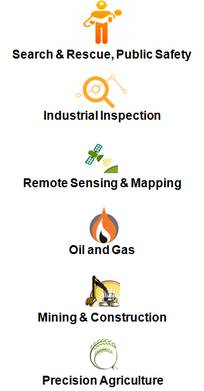
Applications using UAV
The UAV is currently used for various
applications in diverse fields like Disaster Management and Rescue operations,
Mining and constructions, Oil & Gas sector, Industrial / Electrical Assets
inspections, Precision Agriculture and many more
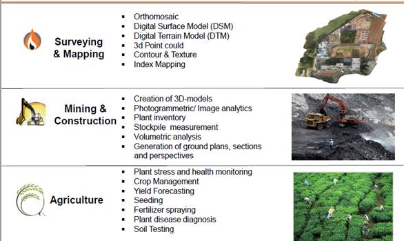
APPLICATIONS
GENERATED PRODUCTS :
·
Volumes
and Profiles
·
Digital
Terrain Model , Digital Surface Model
·
Contours
and Textures
·
3D
Photogrammetric “heads-up” feature digitizing
Basic Operations
The basic operation of UAV is very simple and
includes three simple steps
a)
Flight
Planning and Management
b)
Actual
Flying
c)
Processing
the collected images.
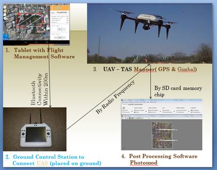
(a) Flight Planning and
Management
There are three components – a Ground
station device, a android based tablet and the Bird.
Ground station :
The Ground station is like a small router device. It connects
the tablet
and the UAV bird.
Tablet :
The Google map in the tablet enables the user to draw his own
area of interest where the flight will be
occurring.
UAV :
It flies to collect either video or still photos.
(b) Actual Flying –
Images or VIDEO
Once the Ground station is activated with the tablet and connected with
the bird, the UAV starts flying and comes back to the original position once it
is over. The images are collected in the SD card. The same can be used for
collection of video streaming during time of disaster or reconnaissance survey
of desired area.
(c) Processing the
collected images
The images are download from the SD card from
bird and transferred to the post processing software. The software creates the
layout from the GPS positions on-board the UAV and tries to mosaic them. The
photogrammetric software derives the 3D points and creates Digital Surface
model and contours automatically.
VIDEO STREAMING: The sensor boarded
can also be used for video streaming while flying over the desired area. The
video images are streamed directly as it flies over the area giving a real
picture of the happening below on the ground for better management and
assessment.
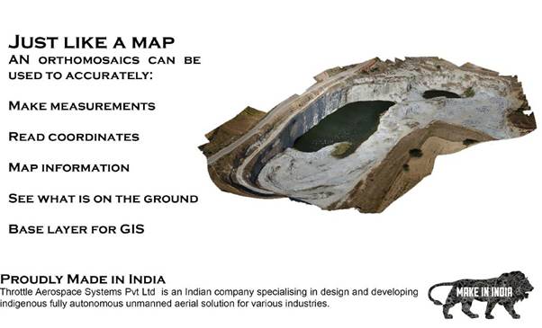
Output from UAV photos is JUST LIKE A MAP
WORKFLOW
Step – I : Use UAV from Throttle Aero Space
Pvt Ltd
a) Use
the Flight Management Software in Tablet (supplied with UAV) to mark the area
b) Fly
the UAV
c) Copy
the images from UAV to computer
Step – II : Use Post Processing Software from
Racurs, Russia
a) Download
the images and create a block
b) Use
GCP and control points to make Block Adjustment
c) Create
3D points / Digital Surface Model
d) Use
the above surface to create ortho-photo
Step – III : Use GIS/Image Processing
software TNTmips from MicroImages,USA
a) Digitistion
of features
b) Attachment
of Data
c) 3D
analysis
d) Modeling
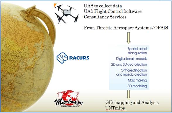
Conclusion : Thus OPSIS can
address end-to-end solution right from collection of images, to process them
and use GIS solution for analysis and modelling all from a single window. The
same can be used for video monitoring too. The services not only include
delivery of system and software but also necessary support and training on the
system.
The UAV from Throttle Aero Space, India, the
processing software Photomod from Racurs Russia and GIS/IP software TNTmips
from MicroImages,USA make the offer one of the most complete and robust
solution in the industry.